

Willapa Bay Lead Entity
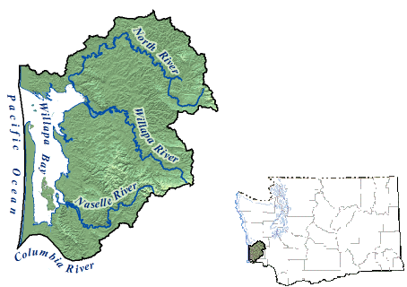
The Willapa Bay Lead Entity’s encompasses Water Resource Inventory Area (WRIA) 24. It’s primary watershed is the Willapa basin, which covers more than 1,000 square miles and includes the Willapa Bay Estuary with over 270 miles of shoreline. In total, there are roughly 745 streams encompassing over 1,470 linear stream miles in the basin. Nearly two-thirds of the land in the watershed is commercial forest lands. Farms make up another seven percent including 1,400 acres of bogs that produce virtually all of the state’s harvest of cranberries.
Commercial fishing has always been an integral part of the local economy. Salmon species generally account for more than 90 percent of the finfish caught in the basin’s waters. The overall goal of the Willapa Bay Lead Entity Strategic Salmon Recovery Plan is to re-establish the connection between fish and their habitat through the identification of human actions and their effects on salmon survival. The plan offers a scientific framework enabling the selection of projects that most effectively restore and preserve the natural habitat features and landscape processes critical to sustained salmon survival. The plan provides scientific support for priority projects through recently completed watershed assessments and various habitat feasibility studies.
Tom Kollasch
Lead Entity Coordinator
1 (360) 875-6735
904 W. Robert Bush Drive
South Bend, WA 98586
The Committee meets the first Tuesday of every month from 5:00 pm to 7:00 pm.